
Niantic Spatial Uses Pokémon Go Data to Power Centimeter-Accurate Robot Navigation
Key Facts
- Niantic Spatial, spun out from Niantic in May 2025, is applying crowdsourced data from Pokémon Go and Ingress to build a visual positioning system (VPS) capable of locating devices to within a few centimeters.
- The company trained its model on 30 billion images captured in urban environments, focused on more than one million precisely mapped game locations.
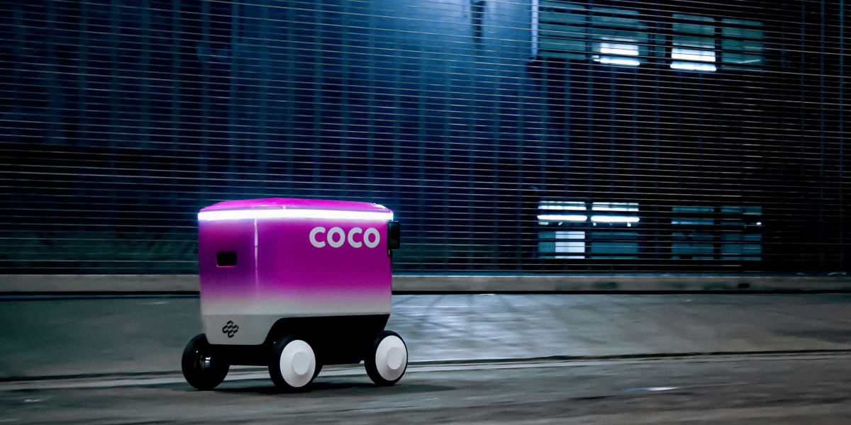
- Niantic Spatial has partnered with Coco Robotics to improve last-mile delivery robots operating in dense urban areas where GPS fails.
- Coco Robotics operates approximately 1,000 sidewalk robots that have completed more than 500,000 deliveries across U.S. and European cities.
- The technology addresses the “urban canyon” problem, where GPS signals can drift by as much as 50 meters.
Niantic Spatial is repurposing the vast visual dataset created by hundreds of millions of Pokémon Go players to help delivery robots navigate city sidewalks with centimeter-level precision, according to a report in MIT Technology Review.
The former Google spinout, which launched the global AR phenomenon in 2016, spun out Niantic Spatial in May 2025 to commercialize its geospatial AI capabilities. The new company is building what it calls a “world model” that grounds AI systems in real physical environments. Its latest visual positioning system determines location based on images of buildings and landmarks rather than satellite signals.
In its first major commercial deployment, Niantic Spatial is working with Coco Robotics, a startup that deploys autonomous delivery robots in Los Angeles, Chicago, Jersey City, Miami, and Helsinki. The partnership aims to solve a persistent challenge for sidewalk robots: unreliable GPS in dense urban settings.
From Mobile Game Phenomenon to Geospatial AI
Pokémon Go drew 500 million installs within 60 days of launch and still attracted more than 100 million players in 2024, eight years after its debut, according to Scopely, which acquired the game from Niantic. Players worldwide pointed their phones at buildings and public spaces while hunting virtual creatures, unwittingly creating an unprecedented labeled visual dataset.
Brian McClendon, CTO at Niantic Spatial, noted the scale of the data collection. “Five hundred million people installed that app in 60 days,” he said. The game encouraged players to visit specific “points of interest” such as Pokémon battle arenas, generating millions of images tagged with highly accurate location and orientation metadata.
Niantic Spatial has clustered its training data around more than one million such locations worldwide. For each site, the company possesses thousands of images captured from slightly different angles, at different times of day, and under varying weather conditions. Each image includes detailed sensor data about the phone’s position, direction, tilt, velocity, and movement.
This rich dataset enabled the company to train a model that can determine its location by analyzing what it sees, even in places it has never visited before. The resulting visual positioning system promises accuracy within a few centimeters using only a handful of snapshots.
Solving the Urban Canyon Problem for Delivery Robots
Coco Robotics operates roughly 1,000 delivery robots that carry up to eight extra-large pizzas or four grocery bags. The robots travel at about five miles per hour along sidewalks and have collectively covered several million miles while completing more than 500,000 deliveries.
Zach Rash, CEO of Coco Robotics, emphasized the importance of precise timing. “The best way we can do our job is by arriving exactly when we told you we were going to arrive,” Rash said. Consistent on-time performance requires reliable navigation that does not depend on GPS.
GPS signals degrade significantly in cities with tall buildings, underpasses, and freeways. Radio waves bounce off structures, causing interference that can make the blue dot on a smartphone drift by 50 meters or more — enough to place a robot on the wrong block or side of the street.
“The urban canyon is the worst place in the world for GPS,” McClendon explained. Niantic Spatial’s visual positioning system uses camera imagery to overcome these limitations by matching what the robot sees against its learned model of the physical world.
John Hanke, CEO of Niantic Spatial, drew a direct parallel between the original game and the new application. “It turns out that getting Pikachu to realistically run around and getting Coco’s robot to safely and accurately move through the world is actually the same problem,” he said.
Technical Foundation and Competitive Context
Visual positioning is not a new concept, according to Konrad Wenzel at ESRI, a leader in digital mapping and geospatial analysis. However, the massive scale of Niantic’s crowdsourced dataset provides a significant advantage. “It’s obvious that the more cameras we have out there, the better it becomes,” Wenzel noted.
Niantic Spatial has been developing its Visual Positioning System for several years using data from both Pokémon Go and its earlier AR game Ingress, launched in 2013. The company announced its Spatial platform in November 2024, offering AI mapping tools for robot navigation and augmented reality applications.
The firm’s latest model forms part of a broader industry push toward “large geospatial models” that help robots and other devices understand and navigate the physical world. Multiple reports indicate Niantic is shifting strategic focus from gaming toward AI and spatial computing following the sale of Pokémon Go to Scopely.
Impact on Robotics and Urban Delivery
For delivery robot operators, improved localization technology could significantly enhance reliability and expand the areas where autonomous vehicles can operate effectively. By reducing navigation errors in challenging urban environments, companies like Coco Robotics can increase delivery density, improve customer satisfaction through more accurate ETAs, and potentially reduce the need for human oversight.
The technology also has potential applications beyond delivery robots. Niantic Spatial envisions its world model supporting augmented reality glasses and other devices that require precise understanding of their physical surroundings. The same visual positioning capabilities that help a robot deliver pizza could eventually power consumer AR experiences that accurately overlay digital content on the real world.
Industry observers see the partnership as validation of Niantic’s long-term investment in mapping and spatial data collection through its games. What began as a mechanism to make AR creatures appear realistically placed in the world has evolved into a foundational dataset for training AI systems to perceive urban environments.
What’s Next
Niantic Spatial has not publicly detailed an expanded rollout timeline beyond the initial Coco Robotics deployment. The company is expected to continue refining its model as it incorporates additional data and expands coverage to more cities and environments.
For Coco Robotics, successful integration of the visual positioning system could accelerate its expansion plans and strengthen its competitive position in the growing last-mile delivery robot market. The startup will likely evaluate performance metrics such as on-time delivery rates, navigation success in GPS-denied areas, and overall operational efficiency.
As more companies deploy robots and autonomous systems in urban settings, demand for reliable, camera-based localization technologies is expected to increase. Niantic Spatial’s massive proprietary dataset gives it a distinctive advantage in this emerging field, potentially positioning the company as a key infrastructure provider for the robotics industry.
The development also raises ongoing questions about the use of crowdsourced location and imagery data originally collected through consumer gaming applications. While Niantic has maintained that player data was collected with appropriate permissions for game functionality, its repurposing for commercial AI models continues to attract attention from privacy advocates and technologists.
Sources
- How Pokémon Go is giving delivery robots an inch-perfect view of the world
- Gotta Catch 'Em All: How Pokémon Go covertly captured your data for years to train a massive AI model
- Pokémon Go Players Have Unwittingly Trained AI to Navigate the World
- Pokemon Go Made Niantic Billions. Now It’s Ditching Gaming For AI.
- Pokémon Go Players Have Been Training an AI to Auto-Complete the Real World